
GIS MAPPING & DOCUMENTATION
Accurate data. smarter decisions. Better infrastructure.
Pipe Scope Pros delivers GIS mapping and utility documentation that helps municipalities, engineers, and contractors manage assets, plan projects, and maintain compliance with confidence.
BUILD A BETTER PICTURE OF YOUR INFRASTRUCTURE
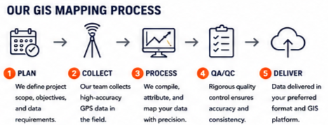
Our GIS mapping and documentation services capture accurate asset data in the field and deliver it in a format that integrates seamlessly with your GIS platform. From collection to deliverables, we help you manage today’s needs and plan for tomorrow.

WHY ACCURATE GIS DATA MATTERS
✓ Improve asset management and decision making
✓ Plan and prioritize capital improvement projects
✓ Maintain compliance with regulatory requirements
✓ Reduce risk and avoid costly errors
✓ Enhance emergency response and operations
✓ Support long-term infrastructure planning
DELIVERABLES
✓ GIS Shapefiles / Geodatabases
✓ AutoCAD Drawings
✓ PDF Maps & Reports
✓ Asset inventory tables (Excel/CSV
✓ Photos & Field Notes
✓ Metadata & Documentation

WHY CHOOSE PIPE SCOPE PROS?
✓ NASSCO PACP Certified Inspectors
✓ State-of-the-Art CCTV Equipment
✓ Specialized in Stormwater Systems
✓ MS4 Compliance support
✓ Fast Turnaround & Reliable Reporting
✓ Serving Municipalities, Contractors & Engineers Across Ohio
✓ Locally Owned. Quality Driven.
NEED A STORM SEWER INSPECTION?
CALL (614) 965-7530
or request a quote online today.